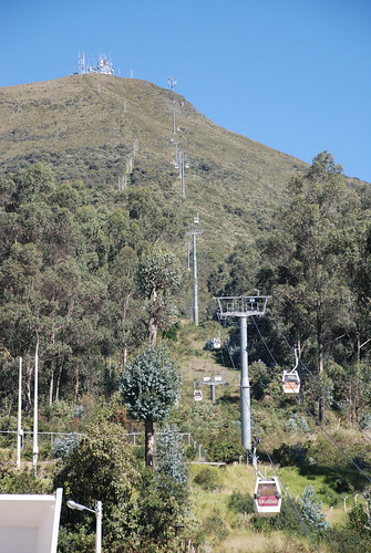
I took a taxi to the base of the Teleferiqo. The driver didn't know the way and the signage only told you you were on the right path after you took the correct turn--no way of knowing if you went the wrong way. He kept asking for directions. The bottom is pretty far up, and I got some of the best views of the three surrounding snow-capped volcanos from there, before the clouds started forming around them.
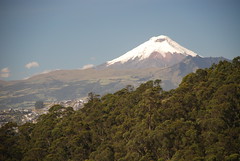
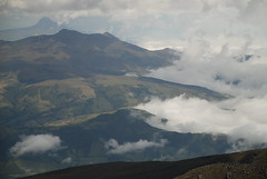
This is Cotopaxi, the second highest mountain in Ecuador, and climbable by an in-shape novice with equipment and a guide.
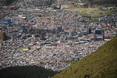
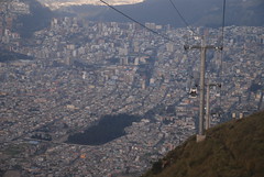
That's my neighborhood from the top of the ride. If you click through to bigger version on flickr, you can see the basilica I climbed to the right. The hostel is almost in the center, a little above the right tip of the park. It's a tallish building whose brick wall on this side has no windows. There are a bunch of red buses parked to the left of it.
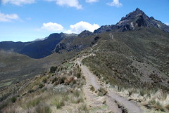
This is the way up to the peak. It would have been no more than a pleasant stroll, except that slowly walking up each hill felt like running at a full sprint. Once I made it over the hills, I had to climb around the right side and up the more treacherous rocky part. It was hand-and-foot climbing, but nothing that required ropes at all. By the time I was to the last 100 feet or so, the air was so thin that I'd get faint with each move. I just had to pause and breathe and it was fine. The refuge where you start the Cotopaxi climb is higher than this peak. If I want to do that, I have some more acclimatizing to do!
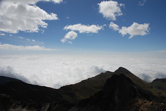
The view from the top was, obviously, spectacular. Everything in the lowlands to the west was covered in clouds, which were beginning to spill over the western cordillera into the depression that Quito is in.
The city lay far below. I looked down on all the planes flying into and out of the airport. Even planes flying over weren't that far away. You can see just how high up the Teleferiqo takes you. Despite a couple layers of sunblock on my face, I came back with a bit of a pink nose and cheeks. Nice oneday adventure.
1 comment:
Amazing. I remember when Betsy and I were in Hawaii. We drove and hiked to the top of mountains there (where there is a government observatory) and looked over hills and valleys shrouded in clouds, watching as the sun and wind continually altered the landscape -- like a living oil painting.
Kind of makes you wish you could fly, doesn't it?
Post a Comment